
A History of LAKE UNDERHILL
Rick’s
CitrusLAND Holiday Blog
Part 1: A Familiar Story; a Familiar Surname
Vehicles by the thousands scurry across the hectic overpass
daily while their first time occupants consider ducking, so as to avoid all the
low flying aircraft. Planes make a final approach above the traffic, each one aiming
for a landing strip that begins at water’s edge, on the north side of Orange
County’s 408. On the bridge’s south
side, pleasure boats pulling skiers maneuver in and out of a maze of wave runners,
while joggers watch the action from a popular lakeside trail. With so much
occurring at this location, one might easily forget that at the center of it
all is a mysterious body of water, known today as Lake Underhill.
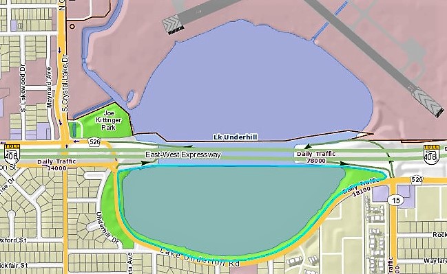
East-West
Expressway (The 408) at Lake Underhill
The East-West Expressway slices the lake in half. Also known
as the 408, travelers on the
east-west toll road have long used the expressway to access East Orange County.
In fact, locals have either crossed over or driven around this lake for nearly a
century.
An ‘Orlando, Underhill
& Conway Express Wagon’ carried passengers and freight here as the
1880s, leaving Conway at 8:30 AM
twice weekly, passing through “Underhill”
about 9 AM, and arriving in Orlando
‘about’ 9:30 AM. For anyone desiring
to return, the ‘wagon’ departed
Orlando at 11:30 AM. The roundtrip fare was 40 cents. What then is the story of
Lake Underhill? Who first settled at this body of water destined to become Lake
Underhill? Or for that matter, who was Underhill?
The lake was not shown on maps prior to 1880, but an Official 1890
Orange County map not only shows the lake, it identifies the body of water as Lake Underhill.
A
Familiar Story:
The lake’s absence from 1880 and earlier maps is misleading. Early
pioneers arriving in Central Florida first settled alongside a narrow
north-south artery, a dirt trail known as Fort
Mellon to Fort Gatlin Road. This old forts trail is one and the same as the
route I call First Road to Orlando (2015
by Richard Lee Cronin). Leaving Lake Monroe, the 1838 trail led south to towns; Maitland,
Orlando, and eventually Pine Castle.
The earliest pioneers ventured into West Orange County as well,
homesteading along yet another military trail, but prior to 1880, few had ventured
east
into the county. The end result was East Orange County developed much later
than the western half.
Surveyors of the 1840s though had charted the entire county. In spring of 1843, Deputy Surveyor Henry Washington completed surveying
Township 22 South; Range 30 East, the region that included Lake
Underhill. Washington’s survey provides our first look at Lake Underhill, and also sheds light on why the 408 slices through
the center of the lake today.

1843
Land Survey by Henry Washington
Lake Underhill is shown to
straddle Sections 29 & 30
Lake
Underhill straddles two, one-square mile survey ‘Sections,’ numbers 29 and 32. Each ‘Section’
contains 640 rounded acres. Between 1842 and 1900, most homesteads most were issued in 40, 80, 120 or 160 acre
increments. Deeds were issued using legal descriptions from these 1840s
surveys. As the ‘Section” line sliced through the body of water east-west known
today as Lake Underhill, the
dividing line for early property owners likewise cut through the lake’s center.
As roads were needed, roads most often kept to the property edges. Hence, the
East-West Expressway’s alignment!
Henry Washington called the water feature he surveyed in 1843 a “pond.” This was not unusual. Few lakes were named by the 1840s
surveyors mapping them.
Most central Florida lakes were named by homesteaders and
developers, with names often being family surnames or locale names. Lake Conway, for example, was named for
Valentine Y. Conway, Florida’s
General Surveyor at the time the lake was surveyed.
The
Familiar Surname:
MIZELL is a
central Florida pioneer surname most often associated with Harry P. Leu
Garden’s, or perhaps the 600 acre Lake
Conway estate. Widow Angeline Mizell
did not however acquire the Leu Gardens land until after her husband’s death, while that huge estate fronting Lake
Conway belonged to the Widow’s father-in-law.
Like father, like son, David
W. Mizell, Sr. & Jr. selected lakefront property in 1860.
The first landowner on the shore of future Lake Underhill was
David W. Mizell, Jr, a native of
Florida born 1833. He bought this
parcel August 1, 1860, at the same
time his father, David W. Mizell, Sr. began accumulating acreage on Lake
Conway.
Within one year of the land purchases, Junior and his brothers
went off to fight in the Civil War. Surviving the War, David returned to Orange
County only to die in an 1870
hometown ambush while he was surviving as Orange County Sheriff.
At the time of Junior’s
death in 1870, his land was nearly
two miles east of the tiny four (4) acre county seat of Orlando. Not until 1875 did Orlando incorporate, and even
then, further development was at a snail’s pace. The lake destined to be Underhill remained well outside of city
limits, although at this time, the lake did begin attracting a little attention
from outsiders.
EAGAN
of Florida’s Panhandle
Kate E.
EAGAN, of Madison County, Florida, purchased 40 acres adjacent to and west of the Widow MIZELL’S property. Kate’s
deed was dated December, 1875, and
had been signed by several Florida Officials, including the Land Commissioner, Dennis EAGAN.
Dennis & Kate (LIVINGSTON) EAGAN were newlyweds. A
Wisconsin native, Kate was born out west while her father served as a Registrar
of Lands. The family moved back to Brooklyn, NY by 1870 though, in time for her to meet and marry Dennis, an Irishman
and Union Infantryman, in 1873.
After the wedding, the Eagan’s moved to Florida.
The Eagan’s purchased land throughout Orange County, but on
January 1, 1877, the couple purchased
40 acres south of and adjacent to Widow MIZELL. Dennis and Kate however did not
relocate to central Florida.
Another 1870s land transaction occurred September 10, 1879. Widow Mizell deeded a 40 acre parcel adjacent to the south
property of her EAGAN neighbor. This parcel was deeded over to Widow Mizell’s
daughter, Lula and husband, Humphrey T. ARNOLD.

1880:
(1) MIZELL land; (2) EAGAN land; (3) ARNOLD land
At the close of the 1860s decade only one individual owned
land at Lake Underhill. By the end of the following decade, three (3)
individuals owned the west lakeshore: Mizell (#1 on map); Eagan (#2 on map) and
Arnold (#3 on map). Two of these three parcels were vacant of homeowners, as
neither Widow Mizell nor the Eagan’s lived lakeside.
The actual name Underhill
for this lake does not appear to have existed as of 1880, but big changes were in store for upcoming decade, which is
where I will pick up in Part Two of my
Holiday BLOG: A Louisville School Board,
on December 13, 2017.

Your Online History Store: www.CroninBooks.com
References
are available upon request, email Rick@CroninBooks.com
Richard
Lee Cronin
Proud recipient of the 2017 Pine Castle Historian Award
No comments:
Post a Comment